|
It unfolds as follows:
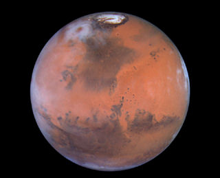
Vast Ice Fields Found On Mars
Life on Mars now a greater
possibility.
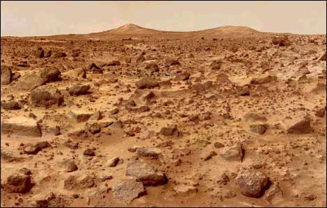
Photo taken on the surface of Mars by the Mars Pathfinder lander (July, 1997).
The ice is believed
to be mixed in with the dirt, rocks and dust to a depth of around 3 feet. It seems to cover a very large area from the southern
polar cap all the way up to about 60 degrees in the southern latitude of Mars. Another find has also been made in the northern
polar cap region.
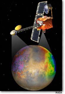
The Mars Odyssey spacecraft
is responsible for the discovery. The first announcement was made in the early part of March, 2002.
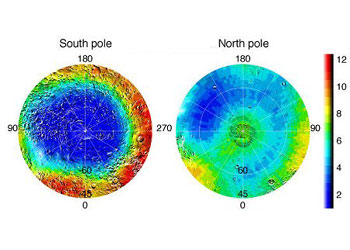
The blue areas of the poles of Mars (colored for easier
identification) show the presence of hydrogen.
This is a strong indicator of large water deposits,
evidently just below the surface of the planet.
Not only
does this indicate a considerable availability of frozen water for our use to assist our living on the planet (for sources
of water, oxygen and hydrogen), it also strongly suggests that life may actually have begun on the red planet, perhaps millions
of years ago.
Does that
mean that some form of life might still be there, beneath the surface, possibly in the dirt or in caves? We don't know.
Who knows what
we might find, hidden within this strange and fascinating planet. Who knows.
Mars Water Report
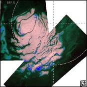
Image survey by Europe's "Mars Express" spacecraft.
In the early part of 2004, the British weekly science journal, "Nature"
reported that a French-led team, utilizing data sent back by Europe's "Mars Express" spacecraft, has discovered that the planet
Mars does indeed hold huge reserves of frozen water in its southern pole.
Water ice, mixed with a large amount of frozen carbon dioxide has been found,
along with icy deposits encrusting scarp areas around the polar cap that seem to be just frozen water, and very large water
ice deposits that seems to be a mix of water and dust.
Our Return To Mars With
The Odyssey Spacecraft
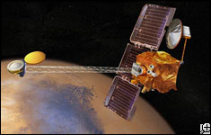
NASA artist's illustration of the Odyssey space craft
orbiting the planet Mars.
On April 7, 2001, a Boeing Delta
II rocket lifted off from Cape Canaveral, Florida carrying the Mars Odyssey spacecraft. On October 23, 2001, the craft went
into orbit around Mars for an extensive geological survey of the Red Planet and a detailed search for water.
If large enough amounts of water
are discovered, human settlement of the planet may become a reality in the not too distant future. In other words, the day
may soon come when some who are living today will experience walking (in space suits) on those red sands and watch the two
moons rise in that strange, pink sky.
And, what about those odd structures
previously detected on the planet? Are they natural formations, as many scientists suggest, or were they created by an intelligence?
Planetary surveys like this one will help to give us the answers.
Martian Volcanoes
Martian volcanoes "Ceraunius Tholus" and "Uranius Tholus," as seen by the
Mars Orbiter Camera. Image acquired March, 2002.
Solar Storm
Radiation-measuring instrumentation knocked out on the 2001 Mars Odyssey by the greatest
solar storms ever recorded.
A NASA artist's conception of the 2001 Mars Odyssey probe
mapping out the planet Mars.
NASA has not been able to put the Radiation-measuring instrumentation back
into service but much valuable data has already been collected and the rest of the probe is functioning well.
The intense solar storms
of late October and in November (2003) caused other damage as well. At least two satellites (orbiting Earth) were damaged,
navigation systems were disrupted, radio broadcasts were interrupted, and there was a large power blackout in Sweden.
Mars Q & A
Q uestions and Answers about the red planet MARS.
Q
- How long is a Martian day?
A
- Our Earth day is approx. 24 hours. A full
day on Mars is 24 hours, 39 minutes and 35 seconds in length.
Q
- How long is a Martian year?
A
- A year on Mars (one revolution around the
sun) spans 687 Earth days. At from 128.4 million to 154.8 million miles from the sun, it takes Mars longer to revolve around
our home star.
Q
- Is Mars as large as our Earth?
A
- The Red Planet is approx. half the size of
our Earth. It is an average diameter of 4,212 miles. That's also about twice the size of our moon. This also results in a
gravity that is only 38 percent as strong as on Earth.
Q
- What is the air like on Mars?
A
- The Martian atmosphere is primarily made up
of three gasses. It's 95.3% carbon dioxide, 2.7% nitrogen and 1.6% argon. The air pressure averages less than 1/100th that
of the Earth's atmosphere. For us, it is almost like being on our moon, which has no air at all.
Q
- What is the temperature on Mars?
A
- At the surface of the planet, it averages
-64 degrees Fahrenheit. However, it can get down to -199 degrees Fahrenheit during the night at the northern or southern poles
and as high as 80 degrees Fahrenheit at the equator during midday periods when Mars is at its closest point to the sun.
Q
- Does Mars have a moon?
A
- It has two moons but they are very small ---
only a few kilometers wide. Images of these tiny moons show us irregular shapes that suggest they may be asteroids that were
captured by the Martian gravity.
Q
- What are the highest and deepest areas on Mars?
A -
The "Olympus Mons" dormant volcano is the highest
point on Mars, topping out at approx. 16 miles high. The greatest canyon ever found in our solar system is on Mars and is
just about 2,500 miles long and six miles in debth in many areas.
Mars Exploration -- 2004
NASA/JPL artist's conception of one of the two Mars Exploration Rovers, from the American spacecrafts "Spirit" and "Opportunity."
From the end of 2003 to the early part of 2004 and beyond, spacecrafts
arrive at the planet Mars. It is the beginning of a new era of interplanetary exploration.
From the European "Mars Express" (Arrival: Christmas Eve - U.S. time),
to the American NASA "Spirit" landing (Date: Jan. 3, 2004 - U.S. time), and the NASA "Opportunity" landing (Date: Jan. 25,
2004 - U.S. time), it is the most comprehensive effort of its kind in all of Human history.
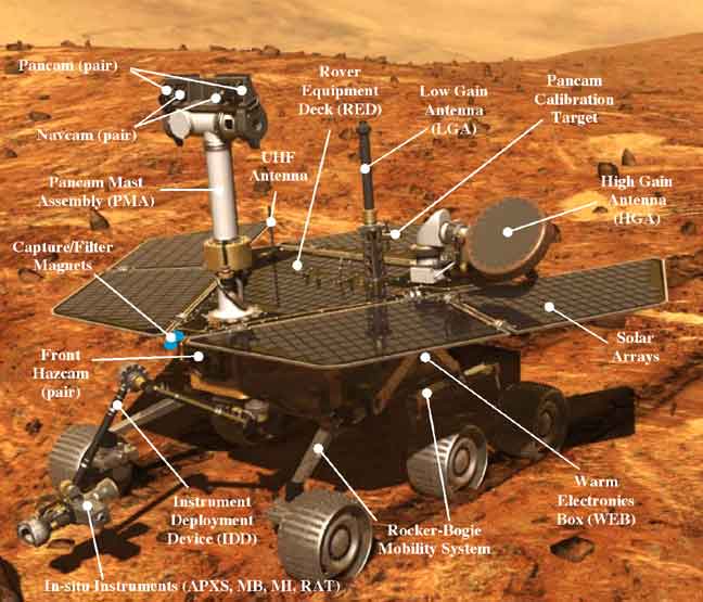
The two identical "Rovers," one from the "Spirit" ship and one from the
good ship "Opportunity," have very sophisticated assignments using panoramic cameras, microscopic imagers, miniature thermal
emission spectrometers, mossbauer spectrometers, alpha particle x-ray spectrometers, rock abrasion tools and magnet arrays.
This page will have up-to-date information and great images, as acquired.
We also offer you a special link to the NASA Mars Exploration Home Page, from which you can keep up with the discoveries as
they happen. The web site link is:
|| NASA MARS LINK ||
IMPORTANT BULLETINS:
Dec. 26, 2003:
Europe's Mars lander vanishes! No signals are detected. If no signals are received, it will be up to the American spaceships
and their landers on Jan. 3rd and on Jan. 25th, 2004. Stay tuned.
Jan. 3, 2004: U.S. NASA Spaceship "Spirit" landed on Mars and
has begun successful transmissions back to Earth! Images follow.
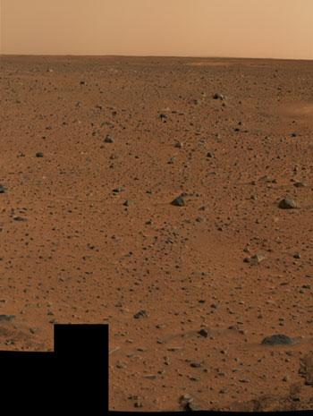
First U. S. Mars Landing
In 2004

NASA depiction of entry into thin Mars atmosphere.
Earlier space survey of area of the Mars landing of Jan. 3, 2004 (seen above this caption).
This Spirit/Rover landing was in this Gusev Crater where many scientists believe water filled the area many thousands of years
ago. It is felt that this area may offer reasonable possibilities for finding signs of ancient life.
The Opportunity/Rover landing, of Jan. 24, 2004, is in the Meridini Plain. It is
an area of gray hematite, a mineral that is often associated with water. It is felt that there is the possibility that it
may have supported life in ancient times.
First Image From the First 2004 NASA Mars Landing
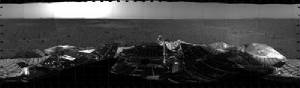
Mosaic image taken by the navigation camera on the Mars Exploration Spirit/Rover.
This is the first and somewhat primitive black and white picture. Very clear, colorful and much more interesting shots follow
this first test effort. (NASA/JPL/Cornell)
Additional NASA links for the latest updated information on the U. S. NASA Mars explorations
beginning in 2004:
|| NASA MARS PROGRAM LINK ||
|| NASA MARS ROVERS LINK ||
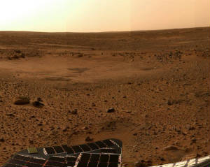
First Color Pictures From The First Jan., 2004 U. S. Landing on The Planet Mars Includes The
Following:
The first color image from the Mars explorations of 2004. This image was received on Jan. 6, 2004.
It is the highest resolution picture ever taken of another planet, up to this time. (NASA/JPL/Cornell)
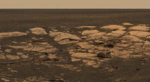
The Best High Resolution Images
Received From Mars
(Received & Posted,
Middle of Jan., 2004)
As of the date indicated above, this is now the very highest resolution image ever received from another
planet. You will notice the prominent depression in the picture. It is one of the areas that was slated for close examination.
(NASA/JPL/Cornell)
Here is the image of the first landing site on Mars in 2004, as photographed by the Rover. (NASA/JPL/Cornell)
IMPORTANT UPDATE INFORMATION
FOR JANUARY 22. 2004 RELEASE
In was announced on this date that, since Wed. AM of Jan. 21st, NASA has received
only intermittent blips from the Rover. It is believed there is a problem with the spacecraft's computerized brain. The exact
cause of the problem has not been determined.
It is considered to be a very serious anomaly on the vehicle. It is said that
the problem might have been caused by a power surge or some sort of software glitch or possibly a temperature-related failure.
All possible efforts are being made to bring the system back to life.
The Second Landing of 2004
Jan. 24, 2004: The "Opportunity" landing craft and its Rover have landed safely on Mars and great images are being transmitted
back to Earth.
For important images and information on this second exploration, see the page
(on this web site) titled, "2nd Mars Landing -- 2004."
As of Jan. 25, 2004...
THE "SPIRIT" ROVER RECOVERING.
After a while, most of the important functions returned.
<><><><><><><><><><><><><><><><><><><><>
IMPORTANT ANNOUNCEMENT
(March, 2004)
<><><><><><><><><><><><><><><><><><><><>
Space scientists made a cautious announcement on March 2nd about finding what
they believe might possibly be signs of water in the soil. We will try to give you the whole story.
The scientists do note that the Rover tracks suggest that the soil contains brine.
Of course brine is salt water. It does seem that the Opportunity Rover is actually going through the Martian equivalent of
mud. The salt in that form of water and mud tends to keep the water from freezing at very low temperatures. In other words,
it does seem that we may have found water that is actually in liquid form!
A sophisticated examination of other data suggests that some of the water is actually
being pressed out of the mud when the Rover passes over the area and that the water then freezes immediately and leaves reflecting
shards of ice behind.
And, in addition, very close-up examinations of the soil reveals life-like features
that look a little like Rotini pasta threads. This and other findings, not yet announced, seem to suggest at least the possibility
of past life on the planet and a few are even pointing out that some form of life may still exist there.
Yes, this could be a very important turning point in our current exploration of
the planet Mars. And, it is only the beginning.
More Signs of Water Found on Mars
By the Mars "Spirit" Rover
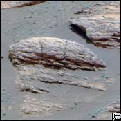
The "Spirit" Rover took this image of rock formations that show ripples that very strongly suggest
the past presence of a truly notable amount of liquid water on the planet Mars.
This image was released by NASA on March 7, 2004. The "Spirit"
Rover also scraped a little hole in one of the volcanic rocks and discovered some shiny material that is felt could be mineral
deposits that crystallized after water had evaporated.
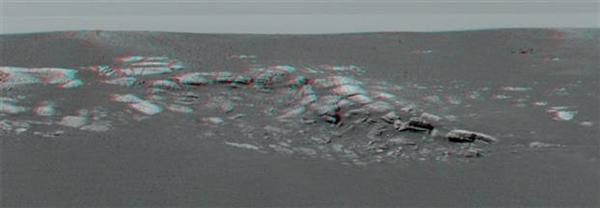
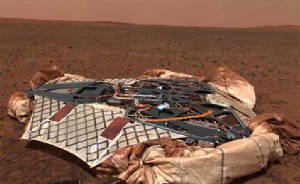
"Spirit" Rover Took a Panoramic Image
of The Bonneville Crater
Landing Site on Mars
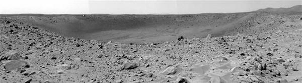
Picture released March 12, 2004 shows the full 650-foot-wide crater. Heatshield and parachute elements
can be spotted with careful examination of the picture. (Release by NASA/JPL)
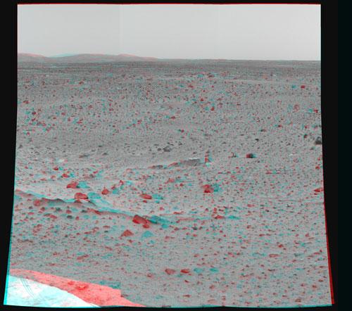
3D IMAGES
FROM MARS
Here is the first image from
the planet Mars in 3D (stereo).
Image: NASA/JPL/Cornell University
To see this image in 3D you will need to obtain special glasses. See below to obtain the necessary
anaglyph 3D glasses (with red & cyan lenses).
The glasses you will need can be ordered
from one of several companies. We recommend either the one listed as rainbowsymphony.com or 3dstereo.com (our favorite).
As an example, go on the http://www.3dstereo.com
web site and choose "Other Stereo 3D Formats" and then, in the "Search For" line, enter the word "Anaglyph," and then go down
to product codes "GLA-PVU" through "GLA-HRC," Our choice would be the very inexpensive cardboard anaglyph 3D glasses in Red
& Cyan (#GLA-CRC).
Such glasses will allow you to view the
various 3D images from Mars, as they come through to us and we post here for you to see and/or to print out. We hope you will
enjoy the view. It's almost like being there.
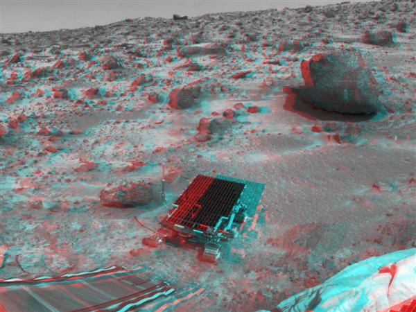
Here is a stereo image taken by "Opportunity's" panoramic camera at Meridiani Planum on Mars,
near the end of Jan., 2004. (NASA/JPL/Cornell)
...and an image from the Pathfinder’s "Sojourner"
The "Opportunity" Rover Lands on and Explores The Planet Mars
On Jan. 24, 2004, The U.S. (NASA) "Opportunity" Mars exploration craft lands on Mars with its Rover, a duplicate
of the "Spirit" Rover that had landed earlier in the month on the opposite side of Mars.
First Color Image From The 2nd Landing
(NASA/JPL/Cornell)
In this first color image from the Opportunity/Rover landing,
you can see slightly lighter colored areas that show initial airbag imacts and the drag trail and the final impact point in
the foreground.
The shade differentiation is believed to be because of the fine dust and powder
of the area where the landing took place. This material was easily marked as the landing impacts occurred with the airbags.
(The landing was in a location identified as "Meridiani Planum.")
A Discovery Is Made
As the mission progresses in the early part of 2004, the "Opportunity" Rover took
this amazing picture of what is identified as "hematite." This is a mineral that is formed by the alteration of other minerals
containing iron. This can occur only with the presence of water or with certain volcanic activity. It is believed that, in
this area, only water could have enabled the creation of this mineral. (Image transmission from NASA/JPL/Cornell.)
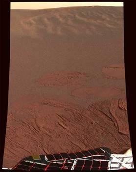
A Martian Sunset
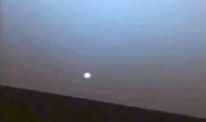
Opportunity's "Rover" captured this panoramic view of a sunset on Mars. You can see the suspended dust
in the slight atmosphere of the planet.
Even though the air pressure is 1/100th that of Earth at
sea level, there is less gravity on the red planet and less atmospheric resistance. Therefore, a much greater particle suspension
is possible than one might imagine.
And, as the sun goes down, the temperature drops extraordinarily low. (See the
"Mars Q & A" page on this site for facts and figures on the conditions on the planet.)
IMPORTANT ANNOUNCEMENT
FROM NASA
December 15, 2004
Opportunity has completed six months of inspecting the inside
of "Endurance Crater" and is ready to resume exploration of the broad plains of the Meridiani region. It
has recently seen frost and clouds marking the seasonal changes on Mars. At this week's conference, rover science-team member
Dr. Michael Wolff of the Brookfield, Wisconsin branch of the Boulder, Colorado-based Space Science Institute is reporting
those and other atmospheric observations. "We're seeing some spectacular clouds,"
Wolff said. "They are a dramatic reminder that you have weather on Mars. Some days are cloudy. Some are clear."
A
portion of Mars' water vapor is moving from the north pole toward the south pole during the current northern-summer and southern-winter
period. The transient increase in atmospheric water at Meridiani, just south of the equator, plus low temperatures near the
surface, contribute to appearance of the clouds and frost, Wolff said. Frost shows up some mornings on the rover itself. The possibility that it has a clumping effect on the accumulated dust on solar panels is under consideration
as a factor in unexpected boosts of electric output from the panels.
Now At Last
You Can See Water
On The Surface of Mars ?
NASA Image
This is a transmitted image from the Opportunity Rover.
Does it really show a puddle of water on the surface of the planet Mars?
The picture was transmitted back to Earth on Dec. 19, 2004. It is felt
by many that this might be brine, water that has a very high salt content. That is about the only way it is believed to be
possible for liquid water to exist at such low temperatures.
SPECIAL
UPDATE
One of our members, Don, has researched
this issue further and has located images that now shows us that the "pool" is a very fine dust like material, not water.
Many originally felt that it could be an exceptionally brackish brine, because that sort of thing seems to have been previously
identified elsewhere on Mars. Not this time. But, we'll keep looking.
Have We found a Meteorite
On the Planet Mars?
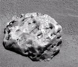
Image released by NASA.
~ Announcement made: Jan. 17, 2005 ~
That's
right. It most certainly looks like a meteorite and the "Opportunity's" Rover has found it. And, the Rover's mini-thermal
emission spectrometer strongly suggests that it could be an Iron meteorite.
The tests show that it is definitely made of metal and it looks very much
out of place where it was found. It's not part of the normal landscape in that area.
This shouldn't be too surprising since there is a large collection of
such items in what we call the asteroid belt. This is an area between Mars and Jupiter and many feel that the two moons of
Mars are asteroids that came a little too close to the red planet and were "captured" by Mars.
The item in the picture above, may well be one of many small meteors that
came from that belt. Earth too, has had its share of such "visitors." This writer owns a genuine example of such a meteor
that struck the Earth (and thus is called a "meteorite"). They make interesting "show & tell" items in our presentations
to schools (under the national "Project Astro").
LATER ANNOUNCEMENT
NASA scientists confirmed (late 1/17/05) that what they thought to a basketball
sized meteorite is, in fact, a genuine metal meteorite. That is their assessment and a rare find it is.
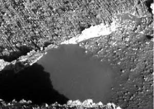
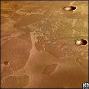
Another Discovery of Water On Mars
As reported in Dec., 2006 and shown on the 'Mars Reconnaissance Orbiter'
photographs of Aug., 1999 and Sept., 2005.
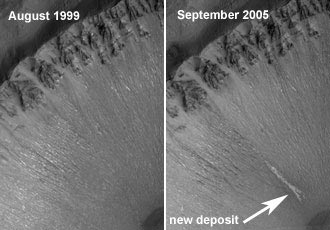
The images show that water must still flow in brief spurts from time to time.
Also, in the summer of 2000, NASA images showed the following evidence of recent
seepage of underground water on the rim of a crater on Mars. The image is as follows:

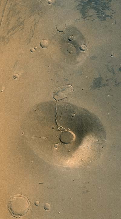
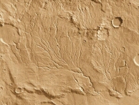
...and the following image shows you a valley network of tributary channels
in the southern highlands of the planet Mars.
Frozen Sea Found
Near Mars' Equator?
Possible frozen sea photographed processed by E.S.A.
"Nature" Magazine (March, 2005) has reported that pictures taken by the European
Space Agency's "Mars Express" indicate the strong possibility of a frozen sea in the area of "Elysium Planitia," which is
close to the Martian equator.
It is theorized that it probably was created from subterranean ice that melted
and came to the surface due to early volcanic activity about three to seven million years ago. It is believed to involve a
considerable amount of water that is around 500 by 560 miles in length and width and could be over 150 feet deep in many areas.
It has also been speculated that the ice may even hold preserved organisms. It
is further suggested that much more water may be found someday beneath the cold surface of Mars, heated by interior temperatures
considerably above that of the surface of the planet.
Life might exist under such conditions. Similar forms of life (extremophiles)
evolved and exist today here on Earth near thermal vents, deep in our own oceans. Who knows what may someday be found in possible
warm subterranean Martian seas?
All sorts of interesting things may be waiting for us there.
The Beginning of a New Era of Discovery
On The Planet Mars
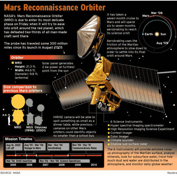
Here are the technical graphics from NASA as supplied to us at the beginning of the mission
(on March 11, 2006).
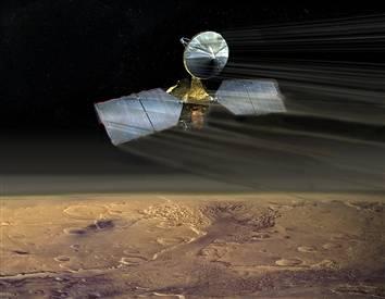
NASA artist's illustration shows Mars Reconnaissance Orbiter skirting the upper part of the
thin Martian atmosphere in aerobraking maneuver. (May 31, 2006)
MARS ORBITER SENDS FIRST SUPER-SHARP IMAGE
Sept. 29, 2006

The first image from the Hi-RISE camera on the Mars Reconnaissance Orbiter shows the floor of the "Ius Chasma" canyon of
the planet Mars. (Image from NASA)
The Hi-RISE camera (High-resolution Imaging Science
Experiment camera) offers this first picture at the highest resolution ever obtained from Mars. The orbiter is now as close
as 155 miles from the surface of the planet. The scientists hope that further images will show further evidence of past water
erosion.
Various mysteries and questionable areas will be able to be examined in
previously unimagined detail. Stay tuned for more images.
NEW MARS ORBITER IMAGE
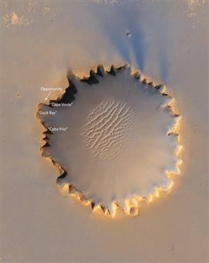
NASA / JPL
As the new images start to come in, we see this spectacular shot of the
Victoria Crater near the equator of Mars. The current "Opportunity Rover" position is noted with the white arrow. (Oct. 6, 2006)
ORIGINAL IMPACT SITE
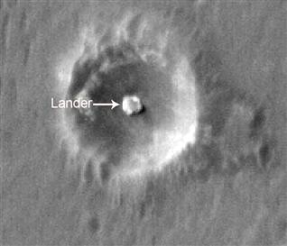
NASA / JPL
This image shows you the impact site for the "Opportunity"
lander that set the "Opportunity Rover" on the surface of Mars and started it's long and wonderfully successful expoloration
of the planet. (Nov. 29, 2006)
Microscopic Tunnels Found In Mars Rock
Indications are that it could be from bacteria of Mars origin.
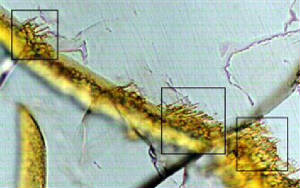
The above is a microscopic image of structures from the "Nakhla" Mars meteorite. The tiny tunnels (usually associated
with microscopic bacterial activity in Earth rocks) can clearly be seen. [ Image: Oregon State University ]
Professor Martin Fisk announced (on March 23, 2006) that an exhaustive study
of the "Nakhla" meteorite (which landed in Egypt in 1911) may show ancient traces of microscopic life from the planet Mars.
This particular meteorite is one of about 30 that have been identified as coming
from the red planet. It is believed that they were rocks that were thrown from the planet due to a major impact many centuries
ago.
This is believed to be the case because these meteorites have gas trapped inside
and the composition of the gas is almost exactly the same as the atmosphere of Mars (as determined by the twin Viking Mars
landers in 1976).
It was noted that all such microscopic tunnel markings on Earth rocks were found
to be the result of bacterial action. This strongly suggests that the tunnels on this Martian rock is indeed biological in
nature.
The Phoenix Lander on Mars
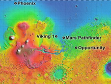
Mars map and location markers
courtesy of NASA.
On Sunday, May 25, 2008, the 9-foot-wide NASA Phoenix Mars Lander reached the red planet, slowed
down from 12,000 mph to 5 mph, using thrusters, a parachute and a little friction from the sparse Martian atmosphere.
NASA/JPL-Caltech/University of Arizona
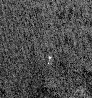
The picture shown here was taken from the NASA Mars Reconnaissance
Orbiter. You can actually see the Phoenix spacecraft with its parachute, as it drops down for a landing. Never before have
we been able to actually see a probe as it descends for a landing on another planet. This is an historic first.
The craft successfully landed in the cold northern polar region and unfurled its
solar panels and raised its weather mast. It's not a mobile unit. It will stay in place, taking pictures, digging trenches,
and analyzing soil samples for the possibility of traces of organic compounds.
It's scheduled for an approx. 90-day mission to try and determine if life might
be or has ever been a possibility on the planet Mars.
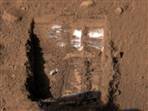
Down and Secure
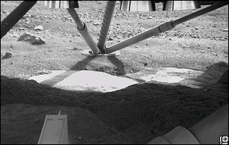
On board camera captures one of the leg elements in place. You can also see the bottom tip of the decent
thrusters at the top of the picture. The landing exhaust seems to have cleared away dirt and dust to reveal the smooth surface
of what is believed to be ice.
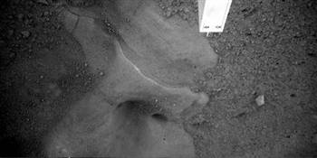
This image taken by the Phoenix Lander's robotic arm camera zeros in on an area under the Lander
that shows what is believed to be exposed ice. This picture, and the one above, were taken and transmitted to Earth on May
31, 2008. The images were released on 6/1/08.
Activity Begins
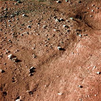
The survey begins on the terrain in the vicinity of the Lander. It was noted that the area looks similar
to the icy ground in the arctic regions of our own planet Earth.
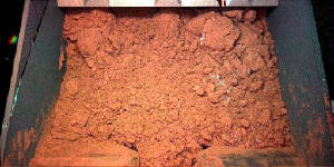
The scoop begins to go into action. Here is a picture taken that shows Martian soil that was extracted
from the surface. It is believed that the white patches, that are visible slightly to the right of the center of the image,
are most likely ice or salts.
All pictures shown here should be credited to NASA, JPL-Caltech, UA, and MPI via EPA.
Ice On Mars
NASA/JPL-CalTech/UA/TAMU
The above image shows what is noted as tiny bits of ice (the small white areas) in
the trench dug by the robotic scoop arm on the NASA Phoenix Lander. It was realized that if they are actual bits of ice and
not salt or some other white substance, in the cold vacuum of Mars, the now exposed ice would immediately vaporize. And that's
exactly what it seems to have done. The ice is no longer there.
|